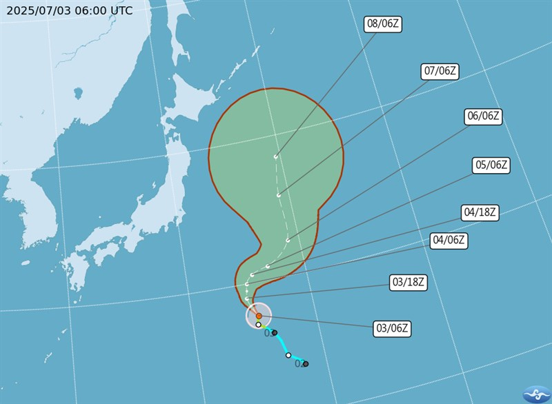
A tropical system developing near the Philippines is expected to strengthen into a tropical depression by Friday, potentially evolving into Typhoon Danas over the weekend, Taiwan’s Central Weather Administration (CWA) announced on Thursday. The system is forecast to bring widespread rain and heat across the island, creating uncertainty for travel, agriculture, and public safety.
🌪️ Forecast in Detail
According to CWA forecaster Chang Cheng-chuan (張承傳), the system is slowly gaining strength and will likely bring localized heavy rain to central and southern Taiwan starting Friday. In the eastern half of the country, sporadic thundershowers are expected.
High temperatures in western Taiwan and Kinmen County are forecast to exceed 36°C, raising heat-related health concerns. Over the weekend, as the system moves closer, daytime highs will slightly drop to 33-35°C, but humidity and rainfall will increase, especially in eastern and southern regions, where localized torrential rains are likely.
Chang noted that while the system may become Typhoon Danas, the current environmental conditions – including moderate vertical wind shear and limited sea surface heat energy – are not ideal for rapid intensification. This creates significant uncertainty regarding whether the storm will make landfall, skirt Taiwan’s east or west coasts, or stay offshore entirely.
🌀 Projected Path and Impacts
- Thursday–Friday: The system moves westward across the seas near Luzon and the Bashi Channel.
- Saturday: Expected to shift northward toward Taiwan, its exact path still unclear.
- Sunday–Monday: The storm may graze Taiwan’s northern edge or pass along its eastern flank, affecting major cities and rural areas alike.
Regardless of the track, the system is expected to dump heavy rain across all regions, particularly in eastern Taiwan (Hualien, Taitung) and the southern counties (Pingtung, Tainan).
If the depression strengthens and shifts closer, Taiwan could experience severe weather alerts, flash floods, landslides in mountainous regions, and disruptions to domestic air and rail travel.
🚨 Government Readiness and Public Advice
While the system’s strength remains uncertain, Taiwan’s local governments are already preparing for worst-case scenarios. The Council of Agriculture has urged farmers to secure greenhouses and drainage, while the Ministry of Transportation and Communications is preparing for potential flight cancellations and road closures.
Residents in low-lying or landslide-prone areas are advised to stay updated on official bulletins and avoid unnecessary travel this weekend. Emergency response teams have been placed on standby in areas likely to be hit hardest.
🌏 Climate Context
Meteorologists say this early-season tropical development is not uncommon given rising sea temperatures in the Western Pacific due to climate change. The region has seen a noticeable uptick in early-season storm formation, with warming waters fueling more frequent and intense tropical disturbances.
FAQs
Will Typhoon Danas make landfall in Taiwan?
It is uncertain. The system may pass along the eastern or western coast or move offshore, but rain is expected islandwide.
Which areas will be most affected?
Eastern Taiwan (Hualien, Taitung) and southern Taiwan (Pingtung, Tainan) will likely receive the most rain.
How strong will the storm get?
Current environmental conditions are not ideal for rapid strengthening, but a tropical depression or weak typhoon is still possible.
Will there be travel disruptions?
Possibly. Heavy rains and winds could affect flights, rail services, and road conditions.
What precautions should residents take?
Prepare emergency supplies, stay indoors during alerts, secure outdoor objects, and follow government updates.


